


la londe 20 mars

thle
User
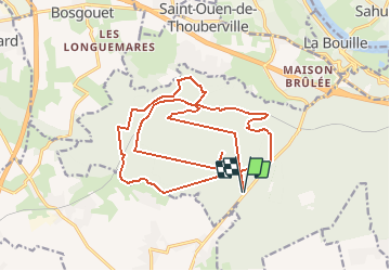

Length
21 km

Max alt
148 m

Uphill gradient
358 m
Km-Effort
26 km

Min alt
68 m

Downhill gradient
359 m
Boucle
Yes
Creation date :
2016-03-19 00:00:00.0
Updated on :
2016-03-19 00:00:00.0
3h12
Difficulty : Unknown

FREE GPS app for hiking
 SityTrail
IGN / Geographical institutes
SityTrail Plus
The world is yours!
About
Trail Equestrian of 21 km to be discovered at Normandy, Seine-Maritime, La Londe. This trail is proposed by thle.
Positioning
Country:
France
Region :
Normandy
Department/Province :
Seine-Maritime
Municipality :
La Londe
Location:
Unknown
Start:(Dec)
Start:(UTM)
347483 ; 5465261 (31U) N.
Comments